Because of the lower attendances recently we may have to restrict the numbers on this walk to one coach, unless the returned letters give over 70 walkers, so get your letters in early.
If your child is leaving school at the end of this school year and you receive your walk letters via school, then please contact the chairman to join our delivery or e-mail lists.
Note: Annual subs due September!.
|
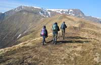
A rather short ‘A’ walk yet a demanding one taking in one of the two exposed high level ridges in the Lake District. Starting at Scales on the A66 (344269) we ascend steadily via Mousthwaite Comb and above the Glendermackin river to Scales Tarn, before making the short traverse across Sharp Edge and the scramble up Foule Crag to Blencathra (2847 ft). The return is to the North West side of the mountain heading to the Cloven Stone boundary post (303288) over Mungrisdale Common, then picking up the Cumbria way to return to Keswick under Lonscale Fell and over Latrigg (1203 ft). |
|||||||
| According to Wainwright, “Blencathra
is one of the grandest objects in Lakeland and compels attention”
so we just had to devise a walk to visit the summit! |
|||||||
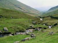
| We will leave the coach in the vicinity of Threlkeld on the A66. After a short distance along lanes, we make our way via Ings and farmland to Wescoe. There we turn northwards and keeping the Glenderaterra Beck on our left, we climb steadily to meet the Cumbria Way. This we follow for about 2 miles to contour round Lonscale Fell. Before making our final descent into Keswick, we will take the opportunity to detour to Latrigg, given the weather, an excellent viewpoint in this area of the Lakes. |
|||||||
|
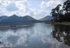
This is an opportunity for ‘C’ walkers to enjoy some spectacular views over Derwentwater. From Keswick we begin a very slow, gentle ascent through Springs Wood to Castlerigg Farm. The path then turns towards the lake and Walla Crag where we can look across Derwentwater towards Cat Bells. Gradually losing height we reach the furthest point of our walk, Ashness Farm, where we can stop for refreshments at the Tea Room and see some unusual breeds of sheep. The return route takes us to Ashness Bridge and we then meander along the lakeside back into Keswick. |